SAND DREDGING NO MORE
Without more consideration.
Reference: 1997 Proposal Beach Replenish Project For Bethany - Fenwick Island, Delaware. Call (215) 656-6734 John Brundage Army Corps of Engineers, and voice that more studies as the one below need their attention. This is the tip of the ICEBERG...... don't wait until more of your money is gone.
Stay tuned here for weekly updates.
These pictures show sand redeposited by nature. Use right-hand mouse button for full size.
Stumps on right side photo are 4x4 posts snapped like twigs.
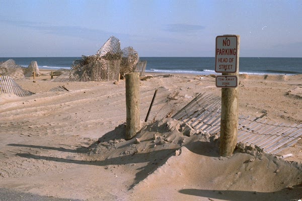
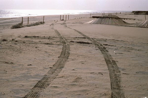
These photos are copyrighted by R. V. L. 1995.
The following letter describes just a few of the inconstancies with existing items.
A Solution is presented, in PART TWO
From:  William J. Winkler   Marine Biologist
     P.O. Box 1400
     Ocean View, DE 19970          (W)302-537-5334

To:  Sara Cooksey   Delaware Costal Management Program, DNREC
     P.O.   Box 1401- 89 Kings Highway
     Dover, DE  19903

Dear Ms. Cooksey,

     Due to political pressure from coastal towns which have built too close to the ocean,
policy of the Department of Natural Resources and Environmental Control (DNREC) has become
more concerned with the protection of privately owned and held property than with Delaware's
natural resources in regard to beach replenishment.   The political tie to beach replenishment is
made very apparent when you consider the fact that State beaches in the same condition as
municipal beaches are not being replenished nor are there any plans to replenish them.
     Unfortunately, the Beach Replenishment Task Force did not agree with any kind of retreat
plan for the coastal towns on the Atlantic Ocean the Delaware Bay.
     Beach replenishment can only occur if DNREC authorizes the permits.   These permits
require utilization of environmental impact studies - studies which clearly state serious
environmental concerns.   Where is the constraint by the people who are in charge of protecting
our environment?
     Due to my work schedule and the time it takes to travel to Dover to review the file, I only
have time to comment on three of these studies.   Please refer to the following studies which are in
your file,  re:consistency for beach replenishment - Bethany,  South Bethany and Fenwick Island.
     I have serious environmental, archeological and economic objections to renourishment as
proposed for the above towns based on the following:

     I.  An evaluation and comparison of Benthic Community Assemblages ... Delaware
Interim Feasibility Study.
     A.  Section 1.1 Background, paragraph two.
     Potential and immediate environmental effects and the exclusion of the recolonization of
the original benthic community.
     Is this not of environmental concern?
     Have computerized numerical models been done on the effects of the inshore area to see
what affects the removal of the shallows would have?
     B. Section 3.4.4 Large Organisms
     The presences of the commercially important Atlantic surf clam in all three habitats may
preclude the use of this barrow area.    See Appendix C (and others A - K), which show that the
abundance and biomass data was not attached in the files.
     The percentage of large razor clams in the sandbar habitat is almost three times greater
than in the deep habitat.
     C. Section 7.1 Habitat comparison, paragraph four.
     I interpret the data in Table 3-5 as having 97.92% of the bivalve E. Directus in the sandbar
habitat to be the adult reproductive part of the population, with the juveniles of this population
being found mostly in the deep habitat as is explained in the biomass interpretation of Section
3.4.3 Biomass.
     Any disruption of the sandbar habitat would be detrimental to the reproductive adults of
the E. Directus population and should be avoided as a barrow site.

     II.  Benthic Animal Sediment Assessment....
     A. IN this report, reference is made to the mole crab and the effects of depositing the spoil
onto the beach.  It states that it takes approximately one year for the adult (reproductive) mole
crab population to recoup if sand is deposited too deep for them to survive burrowing out.
(Suffocating occurs and the entire population in this area is killed.)
     Is any consideration being given to the fact that Ocean City, MD is also planning a beach
replenishment project for the summer and fall of 1997 and the number of miles they are planning
replenish?
     There are approximately 16-17 miles of beach from Bethany to the south limit of ocean
City, 13 of which could be replenished.  Can the mole crab population keep coming back after
such a block of genocide?
     The mole crab is a staple food for the migrating fish and sea birds, including endangered
species like the Piping Plover.   Do we keep killing off species willingly thinking that there are so
many of them that it's no problem?   Where is the constraint?   Is man's beach pleasure and
relatively short term financial investments more important that the natural balance of life on this
planet?
     If beach replenishment has to done, there is an alternative method that was used
by the Army Corps of Engineers of Jacksonville Beach, Fla.    The spoil is deposited just off the
surf zone to crate a sand bar, instead of on the beach.  The ocean will then, especially during the
summer months, deposit the sand "naturally" onto the beach.
     There is both a biological benefit and economical benefit to this.   By depositing the spoil
just offshore, it will create a sandbar acting as a buffer for large swells that could cause beach
erosion.  The sand would be deposited on the beach more gradually, allowing the mole crab to
adjust and survive.  Tourists would not be affected by beach closures and heavy equipment on the
beach.  And, finally, the cost should be considerably less since men and equipment would not be
need on the beach.

     III.   Endangered Species Monitoring Program - reference Loggerhead Turtles
     A. Discussion section.
     1.  The fact that hopper dredging does affect endangered sea turtle populations....
     In the summer and fall of 1994, ironically during the period of beach replenishment in
Dewey Beach, Bethany  Beach, Fenwick Island and Ocean City, 13 loggerhead turtles were
documented killed by drowning per Lee Spence of Mammal Stranding DNREC.
     Although there may have been no clear evidence of a killing by the observers on the
hopper dredge, according to Cecilia Miles (the report's author) in a phone conversation on
1/25/97, "the overflow screening technique is ineffective in proving a kill of a loggerhead."
     Ms. Miles told me about instances where she found pieces of turtle, including intestines,
which were fresh (no smell), and the Army Corps of Engineers wouldn't allow here to enter that as
a kill data for another project.
     She said that due to the heavy equipment, especially the suction pipe itself, a turtle too
large to be sucked through the pipe would be severely battered by the pipe and soft tissue sucked
out of the animal.  This, too, would not show up as any kind of decisive evidence that sea turtles
were being harmed.
     Lee Spence said most if not all of the dead loggerheads found were drowned.  He though
one turtle appeared to have been bludgeoned to death.  Lee said that usually he can detect net
marks on flippers is a turtle is caught in a fisherman's dragnet.   The dead turtles did not show
signs of net damage.
     Ms. Miles told me there should be a qualified independent observer(s) on the dredge
100% of the operation time the dredge was running and that observers should not be relatives or
other connections to the dredging companies.
     Ms Miles specified that in-flow screening is the most effective way to sample what is
entering the dredge.
     Since DNREC's job is to protect our environment, I believe it would best do its job by
making in-flow screening mandatory on all dredges and by having qualified independent observes
on all dredges 100% of operation time.  Volunteers should be recruited if necessary.  Funding
could be obtained from concerned citizens if it is necessary to pay the observers.


     One other comment in reference to the hopper dredge operation:
     In 1988, I observed the Pompano Beach, Fla beach replenishment project.   Great Lakes
Dredging was awarded the bid (and later indicted by the U.S. Department of Justice and the State
of Florida for bid-rigging).
     The spoil that was deposited onto the beach in 1988 included large pieces of coralline
rock, etc, yet, in 1994 the same dredge deposited masticated pieces of shell, etc onto the beach.
     Whatever equipment or process masticates the contents of the hopper should be eliminated,
allowing whole shells to be deposited onto the beach.    Tourists constantly complain to me in my
store that there are no shell on the beach.   Is the masticator a way of destroying tangible evidence
of the destruction of endangered species during the dredging process - covering up large pieces of
sea turtle that may  been sucked up into the dredge?

     IV.  Submerged Cultural Resources Investigation .....
     A.  1.0 Introduction, last paragraph
     Three magnetic targets were identified in the proposed Bethany Beach barrow area
designated as High Probability Targets, which I believe may be eligible for National Historic
Register designation as important historic resources.  It is against state law to disturb an
underwater archeological site within state waters.
     Page 27 - Magnetic target # 25.855
     The Bethany magnetic signature indicates an entire hull of a ship 300 feet long.  This
particular site is possibly "The Three Brothers," a British Navy payroll ship which sank in 1775.
Research on this ship and its possible wreck site have been done by a registered historian for the
State of Delaware.   Among further evidence I have accumulated is the report of divers having
recovered two ship bells from this site(prior to the Submerged Cultural Resources Law).  Both
bells bear the British Crown.
     Other evidence of a British shipwreck are the large numbers of pottery shards found over
the years on the beaches south of Indian River Inlet, some of which bear maker's marks indicating
they originated in Great Britain in the 1700s.
     I recommend that a more detailed Phase II archaeological investigation of this site be
performed before any dredging in this area whatsoever is allowed.
State Archeologist Fay Slocum told me that any borrow of sand from this site would have to be at
least 200 yards away in all directions by state law.  Artifacts from this ship are probably scattered
much farther than 200 yards.   Any disruption to this shoal would be detrimental to Delaware's
submerged cultural resources.  Artifacts from the site could be used on display at the soon-to-be
renovated Indian River Coast Guard Station to tell the story of our maritime history.

     V.  Use of the Ebb Tidal Shoal and the Natural Drift of Sand
     I also strongly disagree with the utilization of the ebb tidal shoal, S.E. Lob at Indian River
Inlet, for the purpose of a borrow site for beach renourishment on Bethany Beach, South Bethany
Beach or Fenwick Island beaches, for the following reasons:
     1.0   The natural littoral draft in Delaware is south to north.   The man-made Indian River
Inlet, with jetties, is an unnatural structure which inhibits the natural flow of sand to the north past
the inlet, creating increasing ebb and flood tidal shoals.
     Even though a bypass system has been installed at Indian River Inlet, there are problems
with its operation (see enclosed letter and photos dated Oct. 25,1996).  The Army  Corps of
Engineering verbally acknowledged that there are problems with the inlet, but as of this date I have
not received a written reply.
     There is a competitive need for the ebb tidal shoal sand in Dewey and Rehoboth beaches,
which is where this sand would have accumulated if it weren't for the inlet and its jetties.  There
has been severe dune and beach erosion to the north of the inlet in recent years and property
damage in Dewey Beach.   Dewey Beach was renourished in 1994, utilizing the Hen & Chicken
Shoal as a borrow site (which is down drift from Dewey Beach).
     According to Joseph Branham, Ph.D. (marine biologist and ocean front resident in Dewey
Beach on New Jersey St.), through completing his own beach profiles and sand sampling, he has
determined that by the summer of 1995 the majority of the renourishment project sand had moved
north to Rehoboth and the remainder was moved by summer of 1996.
     2.)  The renourishment project for Bethany, South Bethany and Fenwick Island beaches is
not necessary.
     The weather pattern in the summer and fall of 1996 included 3-4 tropical storms or
hurricanes approaching from the south.  These storms created large southeast  swell over a period
of several days, which deposited large quantities of sand as far up as the base of the dunes from
Fenwick Island to Cape Henlopen.   Thanks to Mother Nature, I believe there is no demonstrable
need for beach renourishment in the above areas, regardless of the sand loss reported in January
1996, which was used to acquired Federal funds.
     If  profiles were taken during the summer months, they would show little if any loss from
previous summer profiles;  but winter profiles were shown to FEMA.  I consider this an unethical
way of obtaining Federal money, yet,  because the way in which the Federal register is written, it
does not require a waiting period for survey results of the beach profile, therefore it is legal to
apply for funding in this manner.
     3.)  Another issue is horseshoe crabs.  A permit for horseshoe crab (limulus) harvesting
should be mandatory if dredging is permitted.  Even though the hopper dredge is not harvesting to
sell horseshoe crabs commercially, they are removing them from the population permanently.
Joe Weber formally from the "Wave" newspaper reported seeing live horseshoe crabs swimming
in the hoppers of the Great Lakes dredge off  Delaware in the summer of 1994.

     I wish I had more time to devote to expounding on this issue.  I hope you will give serious
consideration to what I have been able to gather for you.
     More importantly, I hope you make your decision(s) in favor of our threatened
environment, protecting our endangered species, preserving our non-replaceable underwater
archeological sites, and protecting the economy of our country  -- saving our hard-earned tax
dollars from unnecessary spending.   It would be refreshing to see real concerns win out over
political pressure.


     Sincerely,

     William J. Winkler
     Marine Biologist
     Retail Store Owner,
     Ocean View,  DE


Part TWO

Letter to Bob Hopman
Chief of Operations
ACE PHL District                                                               Friday, October 25, 1996

[I] Bill Winkler of Sussex County, Del,. former commissioner of the Hillsboro Inlet, Hillsboro,
Fla.;   John Farrow, former mayor of Dewey Beach, Del., and mechanical engineer; and Joe Branham,
ocean front resident of Dewey Beach, Del., and marine biologist, believe you should consider not
approving the Rehoboth-Dewey Beach Replenishment project authorized in "The Water Resources
Development Act of 1996, S, 640."

     It is well known in the ocean engineering community that inlets are the main cause of
downdrift beach erosion if they are not properly maintained.  We believe that if the following problems
are corrected little if any beach replenishment would be needed in Dewey or Rehoboth beaches:


     I.  NO SAND BYPASSING IS PERFORMED DURING JUNE, JULY, OR AUGUST when
the littoral drift is mainly to the north  and would naturally replenish the beaches to the north of the
inlet if not obstructed by the jetties.  Bypassing is halted during these months at the request of Del.
Parks and Recreation, due to tourism.  Yet, massive beach replenishment projects have taken place in
recent years in Dewey, Behtany Beach, South Bethany, Fenwick Island, DE, and in Ocean City, MD,
utilizing heavy equipment, dredge pipes and outflow onto public beaches during these same heavy
tourism months.
          A.  Due to non-operation of the bypass during June, July and August, huge amounts of
          sand accumulate on the south side of the inlet and washes over the south jetty into the
          the inlet (figure 1 not available) and around the end of the jetty.  From there it is
          picked up by the inlet current and carried to the ebb tidal and flood tidal shoals.

          Attempts to stop the overflow of sand are not working.   Continued sand pumping
          seems to be the only solution to this problem.

     II.  PLACEMENT OF SAND ON THE NORTH SIDE OF THE INLET IS MAINLY
BEING PLACED HIGH AND DRY ON THE BEACH,  to rebuild the beach and dunes that protect
the base of the Indian River Inlet Bridge and U.S. Route 1.  Most of the sand bypassed does not
directly enter the water, where it could be carried by the littoral drift to depleted beaches to the north
(Dewey and Rehoboth).

     In this situation of "high depositing," the majority of sand is only moved into the littoral
system during a storm event (Figure 2 not available).  During a storm, massive amounts of sand are
moved in a short period of time (1-3 days).   In a north east storm event, the sand washes through the
north  jetty and over the base of the jetty and sidewalk into the inlet.  Occasionally, the pedestrian
sidewalk on the north side of the inlet is undermined and waves wash a current of sand into the inlet.

     Also during a north east storm event, the littoral drift is accelerated to the south, moving sand
out past the end of the north jetty.   This sand is caught up in the inlet current and carried to the ebb
tidal and flood tidal shoals.  Unknown quantities of sand may also be naturally bypassed back to the
south side of the inlet during strong north easterns.  Refer to Gebert data, Ebb and Flood Tidal Shoals,
ACE/PHL District.

     III.  UNKNOWN QUANTITIES OF DRY SAND ARE ALSO BEING LOST INTO THE
INLET BY HIGH NORTH AND NORTHEAST WINDS (Figure 3 not available).

     Possibly an est-west sand trap could be constructed from layers of dune fence, which have
curved traps.   This would cause sand to accumulate, later to be picked up by the inlet bulldozers and
redeposited onto the beach or kept there as a protective barrier planted with dune grass.

     You may consider increasing the authorized annual bypass from 80,000 +/- cu. yds. (Figure 4
not available) to 160,000 cu. yds.   The sand is definitely available on the south side of the inlet.  As of
this date, the south beach is still overflowing into the inlet as witnessed by Jerry Jones (ACE/PHL) and
Bill Winkler at the meeting of Oct. 18, 1996.

     To compare the effectiveness of increasing the sand bypassed, refer to tables below, which
show the correlation between increased bypassing and the need for beach replenishment downdrift of
an inlet.

     Table 1 represents the cubic yards per year bypassed at the Hillsboro Inlet in Broward County,
FL.   Table 2 shows the change in replenishment needs of Pompano Beach, which is downdrift of the
Hillsboro Inlet Bypass Project.   Please note that no replenishment was needed after bypass dredging
was increased in 1990 to 160,000 cu. yds./yr., despite the occurrence of Hurricane Andrew in 1992.

Hillsboro Inlet,  FL  Dredge Volumes                                    Beach Nourishment Projects, Pompano

TABLE   1                                                                              TABLE    2

1966-70 avg cu yds/yr.  <80,000                                  1970  1,076,000 cu yds  replen. prg.
1979-83 avg cu yds/yr.>  <39,000                                  1983  1,909,000 cu yds  replen. prg.
1986-90 avg cu yds/yr.  >118,000                                1990  scheduled replen. postponed.
1991-96 avg cu yds/yr.  +/-160,000                              1991-96  postponed despite Andrew '92

     Frank Rysavy, chairman of the Hillsboro Inlet Commission, is quoted as saying, "the excellent
beach conditions of downdrift of the inlet in Pompano Beach give testimony to the fact that the inlet is
managed by the best team of inlet commissioners in Florida.   No other inlet in the state equals the
performance of the Hillsboro Inlet.  All of this is done on $500,000/yr. budget."  Commissioners are
locally appointed and work without pay, except for health benefits.

     We, the undersigned, suggest that full control of the Indian River Inlet, DE Bypass System be
made the responsibility of a Sussex County  inlet commission, chartered under the laws of the State of
Delaware.  We believe that local control would better assure proper management of the Indian River
Inlet Bypass System.  the project is currently managed by the Delaware Department of Natural
Resources and Environmental Control, which is located in Dover (Kent County), DE, more than one
and one half hours from the project.

     Of major concern with the Rehoboth/Dewey Beach Replenishment Project is the question,
"How is the 35% of the project's estimated $200 million in inflated dollars to be paid by state and local
sources when there are insufficient tax dollars collected for this purpose in Delaware's hotel-motel tax,
of which 1% is earmarked for beach replenishment?"   Currently, approximately $1 million is
collected from this tax annually, far less than what would be required.

     In recap, we also strongly believe that the Indian River Bypass Project can fulfill the need for
beach replenishment of  Dewey and Rehoboth beaches, as long as the bypass outflow is directed into
the littoral drift (not high deposited) and annual cubic yards are increased to 160,000 cu. yds./year.
To keep the sand from washing into the inlet on the south side, year-round pumping is also necessary.

Sincerely signed.......

William J. Winkler
John Farrow
Joseph Barrow
............................................. phone numbers available upon request.
![]() Weather
Weather![]() Useful
Town Information
Useful
Town Information ![]() Watersports
Ocean Sports
Watersports
Ocean Sports![]()
![]() Dining
Crabs Restaurants
Dining
Crabs Restaurants ![]() Articles
and News
Articles
and News![]() Skateboarding
and Bicycles
Skateboarding
and Bicycles![]()
![]() Golf
Courses Town Parks Camping Vacilities
Golf
Courses Town Parks Camping Vacilities ![]()
![]() Town
Events and Holiday Activities
Town
Events and Holiday Activities ![]() Editorials
Editorials ![]()
![]()